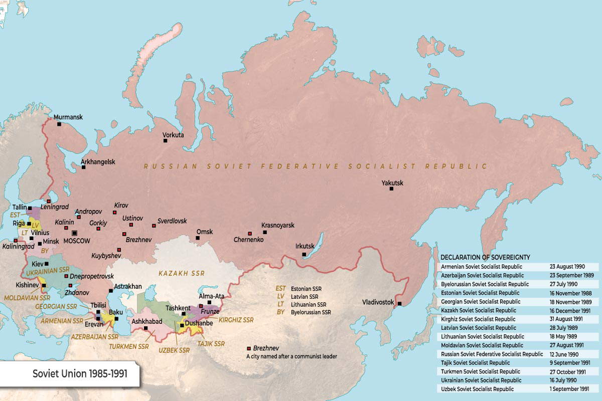
This map illustrates the final years of the Union of Soviet Socialist Republics (USSR), spanning from Mikhail Gorbachev’s rise to power in 1985 to the union’s ultimate dissolution in 1991. It highlights the vast geographic extent of the Soviet empire and the internal political movements that signaled its end.
The Republics of the USSR
The map identifies the administrative divisions that made up the largest country in the world, color-coded to distinguish the various republics:
| Region | Republics & Geographic Context |
| Central Power | Russian SFSR: The massive red territory spanning from Eastern Europe to the Pacific Ocean, serving as the central power of the Union. |
| Central Asia | Includes the Kazakh SSR, Uzbek SSR, Turkmen SSR, Kirghiz SSR, and Tajik SSR. |
| Eastern Europe & Baltics | Includes the Ukrainian SSR, Byelorussian SSR, Moldavian SSR, and the Baltic states of Estonia (EST), Latvia (LV), and Lithuania (LT). |
| The Caucasus | Identifying the Georgian SSR, Armenian SSR, and Azerbaijan SSR. |
Naming the Soviet Era
A unique feature of this map is the identification of cities named after prominent communist leaders, many of which were renamed shortly after the Soviet collapse:
| Former City Name | Modern Name / Context |
| Andropov | Now Rybinsk |
| Brezhnev | Now Naberezhnye Chelny |
| Chernenko | Now Sharypovo |
| Ustinov | Now Izhevsk |
| Gorkiy | Now Nizhny Novgorod |
| Kuybyshev | Now Samara |
The Path to Dissolution
The table on the right, titled “Declaration of Sovereignty,” serves as a countdown to the end of the Cold War. It tracks the legal steps taken by each republic to assert their own laws over those of the central Soviet government:
| Republic | Date of Declaration |
| Estonian SSR | 16 November 1988 |
| Lithuanian SSR | 18 May 1989 |
| Latvian SSR | 28 July 1989 |
| Azerbaijan SSR | 23 September 1989 |
| Georgian SSR | 18 November 1989 |
| Russian SFSR | 12 June 1990 |
| Ukrainian SSR | 16 July 1990 |
| Byelorussian SSR | 27 July 1990 |
| Armenian SSR | 23 August 1990 |
| Kazakh SSR | 16 December 1990 |
| Moldavian SSR | 27 August 1991 |
| Kirghiz SSR | 31 August 1991 |
| Uzbek SSR | 1 September 1991 |
| Tajik SSR | 9 September 1991 |
| Turkmen SSR | 27 October 1991 |