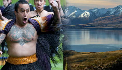
In New Zealand’s North and South Islands, each Māori tribe (iwi) has its own history, founding ancestor or ancestress, tribal territory (rohe), and governance structure, often based around a tribal council known as rūnanga.
The role of Māori tribes has evolved considerably in recent centuries. From the signing of the Treaty of Waitangi in 1840, a turning point in the history of Māori-Pākehā (New Zealanders of European descent), to the most recent initiatives to promote and preserve Māori language and traditions, Māori tribes continue to influence New Zealand’s politics, particularly on matters of land rights and resource management.
What Do We Mean by Iwi?

The Māori name for “tribe” is iwi, which translates as “nation” or “people.” The tribe was the foundation of Māori life before European contact and its largest political grouping. All Māori tribes trace their origins back to the Polynesian sailors who arrived in Aotearoa/New Zealand in their large ocean-going canoes (waka) during the 13th century.
Tribal names honor Māori ancestors, both male and female, and names are usually accompanied by a prefix. The most common prefixes are Ngāti, Ngā, Ngāi, and Te Āti (“the people of” or “the offspring of”), as well as Te Whānau (meaning “the family of”), Te Kāhui (“the assemblage of”), or Ngā Uri (“the descendants of”). The name of the Ngāpuhi iwi, for instance, the largest tribe of the North Island, translates as “The People of Puhi.”

The name of Te Whānau-ā-Apanui, one of the tribes from the Bay of Plenty, can be translated as “The Family of Apanui.” In pre-contact Māori society, each iwi consisted of several related hapū, that is, several clans (or descent groups) that controlled a defined portion of their iwi’s tribal territory. In times of war, the clans came together to defend their sea fisheries, their sacred volcanoes, lakes, rivers, and streams. Marriages were often the key to resolving inter-tribal disputes over land and natural resources and ensuring the survival of the hapū’s members.
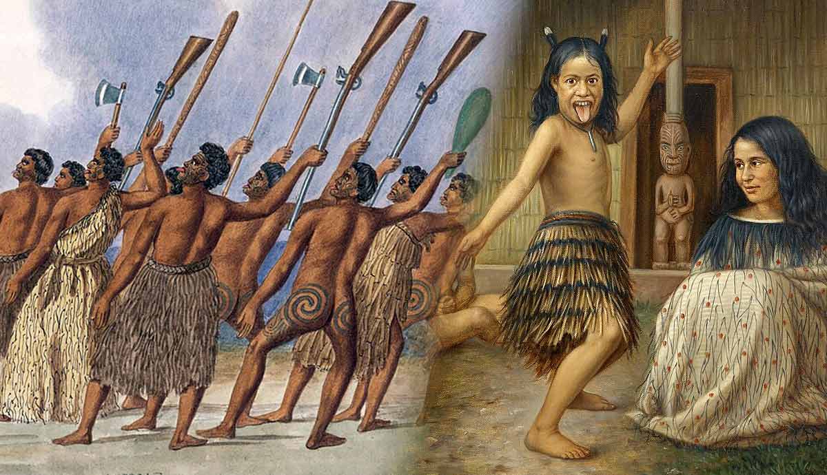
Although some clans moved according to seasonal changes, various hapū usually lived in a single pā (village). During the Musket Wars, Māori clans fortified their pā with multiple rows of single wood palisades, ditches, ramparts, elevated defensive terraces, and fighting stages to protect themselves from attacks by musket-armed enemy tribes. Such villages became known as “gunfighter pā.”

As the population increased, so did the various hapū. In some cases, larger hapū could split into smaller ones. It also happened that small splinter groups, originating from intertribal wars or forced migration, would merge. In turn, each hapū comprised at least one (but often more than one) extended family, which the Māori call whānau, and which continues to form the foundation and basic unit of Māori society. Sometimes large and powerful families, with leaders strong enough to stake their claim, would evolve into a clan, that is, one hapū, in its own right.
The North and the South Islands

Aotearoa/New Zealand consists of two main islands, the North and the South Islands, and more than 700 smaller islands, including Stewart Island, New Zealand’s third-largest island south of the South Island across the Foveaux Strait. The history of the North and South Islands and their varied landscapes is interwoven with the stories, myths, and traditions passed down from one Māori generation to another, from one tribe to another. The Māori name for the North Island, for example, is Te Ika-a-Māui, “the fish of Māui.”
According to Māori myths, the North Island was fished up by Māui, the famous trickster hero of Polynesian and Māori mythology, during a fishing expedition in the Pacific Ocean. His brothers refused to take him with them, so he hid in the canoe. When he revealed himself to them, they were already out at sea.

Here Māui cast a fish hook into the deep waters of the ocean and caught a fish: according to some traditions, it was a flounder, and according to others a stingray. The fish became the North Island. Māui’s brothers disobeyed his prayers and chopped up the fish, cutting off its tail, gills, head, and fins. Hence, the island’s uneven and rugged landscape. The southern part of the North Island, where Wellington was founded between 1839 and 1840, is the head of the fish. The Northland region, home to the Ngāpuhi tribe, represents the tail of the fish, while its backbone runs from Rotorua, with its hot mud pools, geysers, and lakes, to Lake Taupō. Mt Maungapōhatu, whose rugged bush ranges are sacred to the Ngāi Tūhoe, is the heart of the fish.

While the North Island is believed to be Māui’s fish, the South Island is Māui’s canoe. It is indeed known as Te Waka-a-Māui, “the canoe of Māui.” The southern tip of the South Island represents the stern of the canoe, while its northern part north is the canoe’s prow.
Stewart Island, the hilly and forested island 30 kilometers (18-19 miles) south of the South Island, is thought to represent the canoe’s anchor. Today, the Māori call it Rakiura, which means “glowing skies,” but its original Māori name is Te Punga o Te Waka a Māui, which translates as “the anchor stone of Māui’s canoe.”
The Largest Māori Tribes of the North Island

Three of the four largest Māori tribes by population live in New Zealand’s North Island. The Ngāpuhi iwi is Aotearoa’s largest and most influential tribe. Bounded to the east by the Pacific Ocean and to the west by the Tasman Sea, its rohe (territory) occupies the island’s Northland region, the Winterless North, as many call it. Ngāpuhi’s territory stretches east to west from the Bay of Islands to Hokianga Harbor, the latter known among the Māori as Te Kohanga o Te Tai Tokerau, “the nest of the northern people.”
To the south, Ngāphui territory also includes present-day Whangārei, New Zealand’s northernmost city. The Ngāpuhi trace their ancestry back to three canoes, the Matawhaorua, Mataatua, and Ngātokimatawhaorua waka. Kupe, the legendary Polynesian explorer, entered Hokianga Harbor in his Matawhaorua canoe. With his wife Kuramārōtini, he was the first to discover New Zealand, which he named Aotearoa, “the land of the long white cloud.”

The second largest Māori tribe is the Ngāti Porou, the easternmost iwi on the North Island. Its name translates as “the People of Porou,” after their most important ancestor, Porourangi. Their other founding ancestor, Paikea, is said to have sailed to Aotearoa from Hawaiki on the back of a huge whale.
The Māori claim that when Māui fished up the North Island the first peak to emerge from the depths of the Ocean, the first bit of land to be lit by the rising sun was Te Ara ki Hikurangi, known among the Pākehā population as Mt Hikurangi. Today, Hikurangi is the most sacred place of the Ngāti Porou. The tribe’s rohe runs along the coast from Gisborne (and the Te Toka-a-Taiau rock) in the south to Pōtikirua in the north. In its southern part, it extends inland to Waikaremoana.
Mt Ruapehu, in the heart of the North Island, 2021, photograph by Luca Calderone. Source: Unsplash
The fourth largest group is not a tribe, but a tribal league known as the Waikato Confederation. The confederation’s tribal rohe occupies a large area of the North Island, the Waikato region, and extends along New Zealand’s longest river, Waikato, which connects Mt Ruapehu to Lake Taupō. Among the 33 iwi (or hapū, sub-tribes, as some tend to call them) included in the confederation are the Ngāti Mahuta (the first Māori king, Te Wherowhero, belonged to this iwi), Ngāti Tamainupō (named after the tribe’s founding ancestor, Māori chief Tamainu-pō), Ngāti Māhanga (beloved children’s writer and illustrator Melanie Drewery is affiliated with the Ngāti Māhanga), and Ngāti Te Ata (the tribe of one of New Zealand’s most important female leaders Dame Ngāneko Kaihau Minhinnick). All these tribes descend from those who first came to New Zealand aboard the Tainui waka.
The South Island

Of the more than 100 Māori tribes in Aotearoa/New Zealand, the third largest by population is the Ngāi Tahu. The tribe’s name translates as “the people of Tahu,” after Tahpōtiki, one of Paikea’s grandsons (or great-grandsons). The members of the Ngāi Tahu share their ancestors with the Ngāti Porou from the North Island and trace their identity back to Paikea who arrived in New Zealand on the back of a whale to escape his murderous brother.
The story of the Ngāi Tahu is one of migrations, battles, betrayals, and intermarriages with other tribes. Today, their tribal territory covers much of the South Island, stretching from Stewart Island (Rakiura) in the south to Kahurangi Point, the northernmost point of the island’s west coast. Originally, however, the Ngāi Tahu were a northern tribe from the Gisborne District.

From the North Island’s East Coast, they began their migration southward, first to the fertile Heretaunga region near present-day Hastings, then to Wellington, where they settled and ruled the area with other tribes. Eventually, in the early 18th century, some Ngāi Tahu left the North Island, crossed the Cook Strait, and landed on the South Island, Te Wai Pounamu, as it is known among the Māori. Each move was accompanied by bloodshed.
During the early years of their occupation of the South Island, however, the Ngāi Tahu deliberately intermarried with the original resident tribes, learning their traditions and adopting their customs, particularly those of the Waitaha people, such as their understanding of wind patterns.
The Top of the South Island

The top of the South Island is known among the Māori Te Tauihu o Te Waka a Māui, “the Prow of the Canoe of Māui.” Despite being separated from the North Island by the Cook Strait, it is what we could call a transitional area in terms of tribal organization. Most of the iwi living in this region have deep ties with the North Island tribes. Some of them, such as the Ngāti Toa, Te Ātiawa, and Ngāti Koata (“the people of Koata,” named after their founding ancestress), migrated southward from the Taranaki, Waikato, and Wellington regions of the North Island.
The Ngāti Tama, for instance, were originally from Taranaki, and crossed the Cook Strait in the 1820s before participating in the 1835 invasion of the Chatham Islands, the homeland of the Moriori, along with the Ngati Mutunga.

The Rangitāne’s rohe occupies different regions across New Zealand’s two islands. In the North Island, their lands stretch from the mouth of the Rangitikei River in the Manawatū region to the Ruahine Ranges in the east. They also extend into the Horowhenua district to the west and the Wairarapa region in the southeastern corner of the North Island. On the South Island, the Rangitāne’s rohe occupies a significant part of Marlborough (known among Māori as Te Tauihu-o-te-waka), one of the South Island’s 16 regions, including cities like Nelson and Picton and several national parks. The Top of the South Island is also home to two other major tribes, the Ngāti Apa ki te Rā Tō, Te Rūnanga o Ngāti Rarua, and the Ngāti Kuia.

The latter is believed to be the oldest (and largest) iwi in the area. Its rohe stretches from Pelorus Sound (the Hoiere), part of the network of submerged valleys known as the Marlborough Sounds, at the island’s north-easternmost point, to the Nelson Lakes National Park in the south and Taitapu on the west coast.
From the northernmost districts of the North Island to the southernmost regions of the South Island, Māori tribes (iwi) and their leaders continue to influence New Zealand’s politics, representing Māori interests and determination to preserve their language and culture among non-Māori New Zealanders.