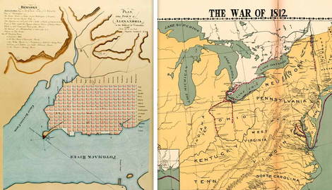
Much like other engagements on North American soil, such as the American Revolutionary War and the American Civil War, the War of 1812 was fought on several fronts across a large expanse of territory. Each key location influenced the course of the war through unique tactical and strategic advantages and challenges. By mapping the conflict, modern historians can ascertain how geography manipulated the course of the War of 1812 from the attempted invasion of Canada at the conflict’s inception through its final battle at New Orleans.
Old Northwest

The Old Northwest region of the United States, composed of the current-day states of Ohio, Illinois, Indiana, and Michigan, witnessed extensive combat during the War of 1812. While the war was not formally declared until the following year, what is now considered the conflict’s first major engagement occurred on November 7, 1811 in northwestern Indiana at a site now known as Battle Ground. There, Governor of the Indiana Territory William Henry Harrison faced off against Tecumseh’s Confederacy.
While marching to the Shawnee stronghold near the conjunction of the Tippecanoe and Wabash Rivers, American forces were targeted by a surprise attack by Native American forces led by Tecumseh’s brother, Tenskwatawa. Known as the Prophet, Tenskwatawa’s ambush fell short of its objective despite the strategic advantage of dense forest terrain and being able to pin their adversaries against the Tippecanoe River. With control of the high ground during the Battle of Tippecanoe, Harrison’s troops successfully countered the Native American assault and destroyed a vital enemy supply hub.
After the War of 1812 officially began, the Old Northwest saw additional exchanges across the territory. In August 1812, the United States surrendered Detroit to the British, limiting access to the Great Lakes. Less than half a year later, the British once again defeated American forces in Michigan at the Battle of River Raisin. The United States did not achieve decisive victory in the Northwest until Commodore Oliver Hazard Perry turned the war’s tide at the Battle of Lake Erie, cementing American control of the region.
Niagara Frontier

Following the American Revolutionary War, England held a significant colonial influence worldwide, including control over the United States’ neighboring northern territory, Canada. After the United States declared war on Britain, American forces marched north to bring the fight to the enemy, attempting to invade Canada at the Battle of Queenston Heights on October 13, 1812. The American invasion was hampered by the restrictive terrain, with US forces having to navigate steep cliffs that proved challenging to safely circumvent.
Despite this early setback, the capture of Fort George in 1813 transferred control of present-day Niagara-on-the-Lake, Ontario, back to the United States. While the region’s open fields facilitated the deployment of American artillery, the proximity of Fort George to the Niagara River enabled the amphibious assault. Strategically, the region offered unopposed access to exploit local waterways and control of the Great Lakes at the mouth of the Niagara River.
While the Niagara frontier offered plenty of action throughout 1813 including the American burning of Niagara-on-the-Lake, the British capture of Fort Niagara, and American losses at the Battles of Stoney Creek and Beaver Dams, fighting largely migrated south and west over the course of the war. However, continued activity in the area provided the United States with a strategic foothold in enemy territory, weakened British alliances with Native American groups, and contributed to logistical difficulties in supplying detached outposts. Simultaneous and subsequent actions in the Great Lakes region highlighted the importance of naval warfare in the War of 1812.
St. Lawrence River and Lake Champlain
Aside from the Niagara region, other waterways in the northeast were strategically vital during the War of 1812. The St. Lawrence River, as a primary supply route for British troops, weapons, and supplies from Upper Canada to Montreal, was a particularly enticing target for American offensive operations. Early in the conflict, the United States burned an unmanned military depot near the St. Lawrence River, but the British responded with two significant victories in the region at the Battles of Ogdensburg and Chrysler’s Farm. By maintaining control of the river, the British maintained access to the pivotal city of Quebec, but defeat at Lake Champlain helped turn the tide of the war.
In 1814, American forces achieved a decisive victory at the Battle of Plattsburgh. Also known as the Battle of Lake Champlain, the engagement gave the United States control of the namesake body of water, giving American forces the upper hand in the war’s northern frontier. As a narrow lake sandwiched between New York and Vermont near the Canadian border, American naval officers demonstrated their skill in fighting close-range warfare on water to defeat the British.
Control of the lakes improved the US negotiating position during the peace talks that resulted in the Treaty of Ghent. Defeating the world’s most capable navy under challenging conditions at Plattsburgh near Britain’s operational headquarters, in addition to unexpected success at the Battle of Lake Erie, was a major success for the nascent US navy.
Chesapeake Bay

The War of 1812 was fought on considerably different terrain further south in the Chesapeake Bay region. Early in the conflict, British forces exploited vulnerable open fields, urban areas, and strategic inlets for military advantage. In May 1813, the Redcoats destroyed an American military depot in Havre de Grace, Maryland, looting the town for supplies.
Closer towards the capital of the United States, weak barricades and defenseless avenues of approach enabled the British to achieve swift victory at the Battle of Bladensburg in August 1814. Following the collapse of the American defenses, the British marched into Washington DC and set the White House, the Capitol building, and other government facilities ablaze in a crushing symbolic defeat for the United States. For the remainder of the war, President James Madison fulfilled his commander-in-chief responsibilities from the Octagon House and Seven Buildings near the destroyed capital.
While urban areas in the highly populated Chesapeake region proved susceptible to British attacks, American fortified defenses in the region held strong. The heavily defended island of Craney Island resisted British assaults in 1813, and one year later, American forces successfully repelled the overnight British bombardment of Fort McHenry. The successful defense of the fort prevented the British from seizing Baltimore and was celebrated by a poem by Francis Scott Key, which became the American national anthem more than a century later.
Southeast

During the War of 1812, fighting in the Southeastern United States primarily consisted of engagements between American forces and Native Americans in the Creek War. Also known as the Red Stick War due to the Creek-affiliated Red Stick tribe’s opposition to American settlers despite its sister clan’s accommodations, the Creek War was part of the larger conflict between the United States and England. Although Tecumseh travelled south to encourage the Red Stick faction to join the war effort in 1811, the Creek War did not begin until 1813.
On August 30, 1813, the Creek War expanded the War of 1812 in southern states with the Fort Mims Massacre, where hundreds of American citizens and militiamen were slaughtered by the Red Sticks. Future president Andrew Jackson led a counteroffensive against the Creeks, navigating dense Alabama terrain and swamps in the Battles of Tallushatchee and Talladega. By March 1814, Jackson led American troops to a decisive victory that all but ended the Creek War. In the Battle of Horseshoe Bend, the United States neutralized over 800 Red Stick warriors.
Victory on southern battlegrounds and exploitation of Native American vulnerabilities led to the opening of land for American settlement in modern-day Georgia and Alabama. The 1814 Treaty of Fort Jackson surrendered over 23 million acres of Creek land to the United States. In addition to significant territorial gains, Jackson’s actions in the southeast contributed to his rise as a national hero alongside further success in the Gulf Coast region.
Gulf Coast

After achieving victory in the southeast, Jackson’s forces traveled west in one of the best-known engagements of the War of 1812, the Battle of New Orleans. Prior to the clash, Jackson’s capture of Pensacola, Florida rid the British from a Spanish fort in the Gulf Coast in November 1814. One month later, however, British naval triumph on Lake Borgne allowed the British army under Edward Pakenham (the Duke of Wellington’s brother-in-law) to land troops near New Orleans to prepare for the assault of the city.
In the final major exchange of the War of 1812, the Battle of New Orleans took place on January 8, 1815. Although the Treaty of Ghent had been signed the previous month, it had not yet been ratified and news of the peace agreement did not reach the Gulf Coast. Jackson prepared his diverse army, composed of regular American soldiers, militiamen, Native Americans, and free African Americans, for battle against Pakenham’s numerically superior British force.
Fought near Chalmette Plantation in New Orleans, the ensuing battle was an unmistakable victory for the United States. By fortifying his position with a series of earthworks and deploying his forces in staggered defenses, Jackson’s men inflicted over 2,000 British casualties, including Pakenham himself, while suffering only 70 themselves. The remarkable American victory bolstered Jackson’s previous successes in the southeast, helping the general gain a degree of popularity and recognition that would eventually see him become president in 1829.
The course of the War of 1812 saw fighting gradually shift from the north in Canada all the way south to New Orleans, where Jackson’s men won their crushing victory in the final engagement on the conflict.