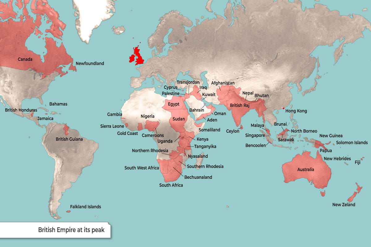
This map illustrates the British Empire at its territorial zenith, approximately in 1921. At this point in history, following the mandates granted after World War I, the empire covered roughly a quarter of the Earth’s total land area and governed one-fifth of the world’s population, famously described as “the empire on which the sun never sets.”
Global Reach by Region
| Region | Key Territories & Dominions |
| The Americas | Canada and Newfoundland (North); British Honduras, Jamaica, and the Bahamas (Caribbean/Central); British Guiana and the Falkland Islands (South). |
| Africa | A near-continuous “Cape to Cairo” corridor including Egypt, Sudan, Kenya, Rhodesia, and South Africa, along with West African holdings like Nigeria and the Gold Coast. |
| Asia | The “Jewel in the Crown” British Raj (India, Pakistan, Bangladesh, Myanmar), along with Ceylon, Malaya, Singapore, and the trading hub of Hong Kong. |
| Oceania | The massive continental dominions of Australia and New Zealand, plus various Pacific island groups like Fiji and the Solomon Islands. |
Key Strategic Ports & Mandates
| Category | Strategic Significance |
| Middle East Mandates | Following WWI, Britain gained control over Palestine, Transjordan, and Iraq, securing land routes to India and emerging oil interests. |
| Choke Points | Control of Gibraltar (entrance to the Med), the Suez Canal (via Egypt), Aden (Red Sea exit), and Singapore (Malacca Strait) ensured naval supremacy. |
| African Mandates | Acquisition of Tanganyika (formerly German East Africa) and Cameroons after WWI consolidated British holdings in the continent. |
Historical Context of the Peak
| Aspect | Details |
| The 1921 Peak | The empire reached its greatest extent ($35.5$ million $\text{km}^2$) after incorporating former German and Ottoman territories as League of Nations mandates. |
| Dominion Status | Large settler colonies like Canada and Australia were effectively self-governing “Dominions,” though still legally tied to the British Crown. |
| Decolonization | While this map shows the peak, the interwar period also saw the rise of independence movements, particularly in the British Raj and Egypt, signaling the eventual decline. |


