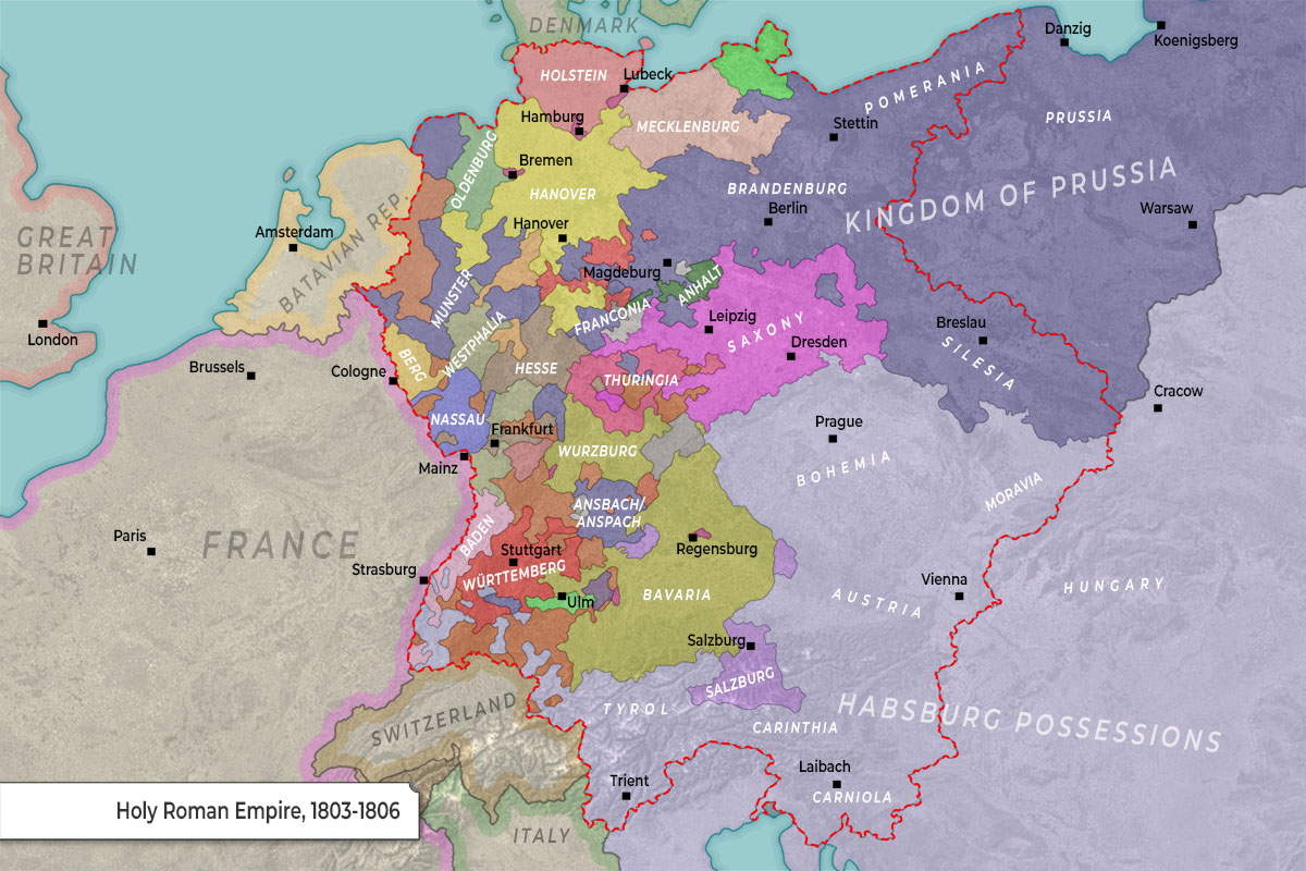
This map illustrates the Holy Roman Empire (HRE) during its final years, specifically between 1803 and 1806. This was a period of massive territorial consolidation triggered by the Napoleonic Wars and the Reichsdeputationshauptschluss (1803), which abolished many smaller ecclesiastical states and free cities.
Major Power Blocs & Territories
The HRE at this time was dominated by two rival powers, though it still contained several medium-sized states that would later form the basis of modern Germany.
| Power / Region | Primary Territories Shown | Key Cities |
| Habsburg Monarchy | Austria, Bohemia, Moravia, Tyrol, Salzburg, Carinthia | Vienna, Prague, Salzburg |
| Kingdom of Prussia | Brandenburg, Silesia, Pomerania, West Prussia, Ansbach | Berlin, Breslau, Danzig, Warsaw |
| Major Electorates | Saxony, Bavaria, Württemberg, Hanover, Baden | Dresden, Munich, Stuttgart, Hanover |
| Regional Clusters | Westphalia, Hesse, Thuringia, Franconia | Frankfurt, Cassel, Münster |
| Foreign Neighbors | France, Batavian Republic (Netherlands), Denmark | Paris, Amsterdam, Copenhagen |
Key Geographical & Political Features
-
The “Red Border”: The dashed red line represents the official boundary of the Holy Roman Empire. Notice that large parts of the Kingdom of Prussia (in the east) and some Habsburg possessions (like Hungary) sit outside the Empire’s jurisdiction.
-
The Rhineland & France: To the west, France has expanded to its “natural borders” at the Rhine. The pink shaded area represents French-controlled or annexed territory, including cities like Cologne and Mainz.
-
The Batavian Republic: This was a French client state (modern-day Netherlands), shown in pale orange to the northwest.
-
Consolidation in the South: You can see the significant size of Bavaria, Baden, and Württemberg. Napoleon encouraged the growth of these states to serve as a “Third Germany” buffer against Austria.
-
Northern Buffer: Hanover is prominently featured in the north, which at the time was in a personal union with the British monarchy.
Historical Context: The End of an Era
This map captures the Empire on the brink of extinction. In 1804, Napoleon declared himself Emperor of the French; in response, Francis II declared himself Emperor of Austria. Following the Battle of Austerlitz and the formation of the Confederation of the Rhine, the Holy Roman Empire was formally dissolved in August 1806.


