
During Roman times, the empire stretched from Britain to the Middle East, held together by fortified cities, sprawling forums, aqueducts, and military camps. Sites like Diocletian’s Palace in Split, the arena in Nîmes, the Roman theater in Cartagena, and the arches of Narbonne still stand, embedded in modern cities. These places weren’t isolated. They were part of a connected system. To move troops, goods, and information efficiently, Rome engineered long-distance roads, paved in stone and built to last across mountains, coasts, and frontiers. Many of these ancient routes, remarkably, still exist today: walkable, visible, and often hiding beneath our everyday paths.
1. Via Appia (Appian Way), Italy

Once dubbed the Regina Viarum, the Queen of Roads, the Via Appia is one of the oldest and most fascinating Roman roads still in existence. Built in 312 BC by Appius Claudius Caecus, it connected Rome to Brindisi, serving as a vital military and trade route for centuries. Today, it offers a journey not only through time but also through serene countryside and ancient ruins.
A walk or bike ride along the preserved stretch near Rome’s Porta San Sebastiano leads you past catacombs, aqueduct remains, and centuries-old tombs like the Cecilia Metella Mausoleum. The cobbled stones underfoot are original in parts, worn smooth by legionnaires, pilgrims, and merchants.
The Via Appia offers a rare chance to walk the same road that once carried emperors, armies, and philosophers. With wildflowers lining the path and cypress trees casting shade, it feels timeless.
2. Via Flaminia, Italy

Not all roads lead to Rome. Some lead you back in time. The Via Flaminia, carved into Italy’s landscape in 220 BC by the censor Gaius Flaminius, once carried Roman legions north to the Adriatic. Today, fragments of it survive like whispers beneath the modern world, threading through Umbria and Le Marche, past green hills and forgotten shrines.
Start near Rome’s Porta del Popolo, once the road’s grand entrance. Venture farther and you’ll find ancient tunnels carved into rock, bridges like Ponte di Augusto in Narni, and arches still holding centuries of silence. These aren’t tourist traps. They’re quiet places where the past hasn’t been cleaned up for show.
3. Via Aurelia, Italy

The Via Aurelia was built around 241 BC to connect Rome with the coastal cities of Etruria, eventually reaching all the way to modern-day France. Originally constructed for military logistics, it later became vital for trade and civilian travel along the Tyrrhenian coast. Today, much of the ancient route is followed by the Strada Statale 1 (SS1), a major highway still in use.
Travelers can explore surviving Roman sections near Civitavecchia and Pisa, where original paving stones and engineering elements are visible. The Roman bridge of Vada and parts of ancient roadbeds offer glimpses into its construction. Unlike more preserved tourist routes like Via Appia, Via Aurelia has been overlaid by modern infrastructure, but its historical footprint remains important.
It’s ideal for those driving the coast who want quick detours into Roman history without straying far. Look for roadside ruins, preserved milestones, and Roman engineering integrated into small towns along the way.
4. Via Augusta, Spain

Ready to time travel without leaving the sunshine behind? Say hello to Via Augusta, the longest Roman road in Hispania, stretching over 930 miles from the Pyrenees to Cádiz. Built in the 1st century BC and named after Emperor Augustus, it followed the Mediterranean coast, linking key Roman cities like Tarraco (Tarragona), Valentia (Valencia), and Cartago Nova (Cartagena).
Today, bits of it still snake through modern Spain. You’ll spot Roman milestones, crumbling bridges, and sections of stone road hiding beside highways. Want to see it up close? Head to Tarragona, a UNESCO site, where you can walk real Roman pavement and imagine traders, soldiers, and dignitaries doing the same.
5. Stane Street, England

Built by the Romans in the 1st century AD, Stane Street was a direct route from Londinium (London) to Noviomagus Reginorum (Chichester), about 57 miles as the legionary marched. Like most Roman roads, it didn’t care much for the terrain; it cut straight through hills, forests, and marshes with characteristic Roman stubbornness.
These days, it’s not a single clean stretch. You’ll find parts buried under A-roads, farm tracks, and footpaths. But many sections still exist, especially around Epsom, Dorking, and Pulborough. There’s no need for tickets or tours. Just good boots and a map.
It’s a walk through two thousand years of British soil, where old meets ordinary. You’ll pass by Roman tiles in hedgerows, Saxon churches built nearby, and modern fences bisecting something older than England itself.
6. Watling Street, England

Watling Street was one of Roman Britain’s main roads, built over an existing Iron Age track. It connected Dover to London, then continued northwest through St. Albans, Towcester, and on to Wroxeter. Constructed in the 1st century AD, it was used for military movement, trade, and administration.
Today, much of the original route is covered by major roads, including the A2 and A5, still in daily use. You can identify some sections by Roman-era place names or visible straight-line alignments. A few isolated stretches remain in rural areas, walkable and marked by signage or interpretation boards.
Notable sites along Watling Street include the site of Boudica’s last battle, Roman Verulamium (St. Albans), and various Roman milestones. Though it’s fragmented and altered, the route’s influence remains strong in the layout of towns and the British road network.
7. Via Egnatia, Albania, North Macedonia, Greece, Turkey

The Via Egnatia was built in the 2nd century BC by the Romans to link the Adriatic coast with Byzantium (modern-day Istanbul). It ran over 1,100 kilometers through what is now Albania, North Macedonia, Greece, and Turkey, connecting important Roman colonies, military outposts, and trade hubs across the Balkans.
It started in Dyrrachium (Durres), passed through Lychnidos (Ohrid) and Thessalonica (Thessaloniki), and terminated at the Bosporus. It was the main east-west route of the Roman Empire in the Balkans and played a key role in military campaigns and commerce.
Today, stretches of the road still exist, some walkable, others buried under modern roads like Greece’s Egnatia Odos (A2) motorway. Notable remains include Roman bridges, paving stones near Philippi, and city gates in Thessaloniki.
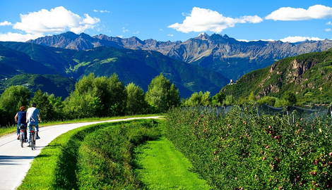
8. Via Claudia Augusta, Italy, Austria, Germany

Via Claudia Augusta was a Roman road completed in the 1st century AD, built to connect northern Italy with the Danube region. It stretched from Altinum (near Venice) and Hostilia (on the Po), crossed the Alps via the Reschen Pass, and ended in Donauwörth, Germany. Originally used for military supply and trade, it became a key north-south route through the Roman provinces.
Nowadays, it’s one of the best-preserved Roman roads for modern travelers. Much of the route has been reconstructed as a long-distance cycling and hiking path, complete with signage, rest points, and mapped detours for scenic and historical sites. It passes through Trentino, South Tyrol, Tyrol, and Bavaria, with visible Roman relics like bridges, milestones, and roadbed remnants.
If you want an accessible route with strong infrastructure, real Roman archaeology, and Alpine scenery, this one’s fully equipped for modern exploration.
9. Via Domitia, France

Via Domitia was the first Roman road built in Gaul, laid out in 118 BC to connect Italy to Spain across what is now southern France. It ran from the Alps at Montgenèvre through Nîmes, Narbonne, and Perpignan, linking up with the Via Augusta near the Pyrenees. Its main purpose? Move troops, control territory, and facilitate trade across the province.
Parts of the road still exist today, some of the best-preserved can be found in Narbonne, where the original paving stones are visible in the town center, and in Ambrussum, where you’ll see an intact Roman bridge and sections of roadbed.
You won’t need a Time Machine. Just decent walking shoes. The route overlaps with modern hiking trails and passes Roman ruins, aqueducts, and amphitheaters.


