An ominously named landscape of bleak, almost alien beauty, the Scablands in southeast Washington State is a geological wonder that holds many secrets and fascinating facts. It is a truly unique place that enthralls visitors of all kinds, from scientists to hikers to photographers, who come to marvel at its incredible forms.
Here are 6 interesting facts about the Scablands!
1. The “Channeled Scablands” Was Named by a Geologist

The first settlers in the area were not impressed with the quality of the soil in the Scablands. To them, the area was useless and generally ignored. To geologists, however, the region held great interest.
Geologist J Harlen Bretz of the University of Chicago named the area the “Channeled Scablands” in 1920 while conducting a geological study of the area. He proposed the theory that the Scablands was created by a massive flood. These floods carved approximately 150 channels known as “coulees” into the bedrock. These coulees are hundreds of feet below the original surface, and while spectacular, they held little value for the pioneers and settlers wishing to create a new life in what would become Washington State.
2. The Scablands Is the Result of Massive Flooding

At the end of the last ice age between 15,000 and 13,000 years ago, periodic floods known as the Missoula Floods swept through eastern Washington and down the Columbia River Gorge. The ice dam on the Clark River Fork melted and re-froze numerous times, causing massive floods to sweep down into the lands below, carving out paths through the basalt.
Research by hydrologist Jim O’Connor and scientist Gerardo Benito shows evidence of at least 25 such floods. Geologist R.B. Waitt Jr. argues that there were at least 40 such floods, each one occurring every few decades over a period of 2,000 years. The largest of these floods is estimated to have discharged 2.4 cubic miles of water per hour—13 times that of the Amazon River. With raging torrents traveling up to 80 miles per hour, the effect on the landscape was powerful.

J Harlen Bretz first proposed his theory of these floods in 1923 and encountered much derision from his peers. How the Scablands was formed was a subject of great academic debate among geologists, which lasted for many decades.
Although Bretz proposed the idea of the Scablands being formed by a great flood, he had no solid ideas as to what could have caused this flood. Geologist Joseph Thomas Pardee added to Bretz’s theory in this regard and suggested that the floods were the result of the draining of a glacial lake. After three decades of painstaking work in the field, Pardee concluded that Lake Missoula in western Montana was the lake in question.
It was eventually accepted that Bretz was correct in his thinking. As the decades passed, Bretz’s and Pardee’s theories garnered more support as evidence mounted. Research in open-channel hydraulics in the 1970s helped push the theories further. Satellite imagery provided by NASA helped solidify this theory, as it clearly showed evidence of the land being carved by megafloods. In 1979, Bretz received the Penrose Medal, the highest honor awarded by the Geological Society of America.
Such was the power of the Missoula Floods that geologists have calculated that they actually caused earthquakes as the walls of water thundered through the landscape.
3. The Scablands Has a Shrub-Steppe Ecosystem

The Scablands constitute part of the shrub-steppe system of the western part of the United States. This system is characterized by low-rainfall natural grassland with few trees but enough moisture to support perennial groundcover. The region is very windy, which discourages tree growth and assists in the spread of grass seeds.
Despite being a barren wasteland as far as farming is concerned, the ecosystem is bountiful in unique flora and fauna that make their home in this wilderness. Ground squirrels and marmots live amongst the shrubs while grazing mammals such as deer, elk, and antelope are common. Efforts to introduce pronghorn antelope back into the ecosystem were made in the 1930s, 1950s, and 1960s. Although rare, the species is slowly growing in number and currently stands at around 250 individuals, according to a 2023 report.
In the skies, hawks, falcons, and owls scan the ground for their next meal, while predators on the ground, such as snakes and badgers, burrow into the earth.
4. Dry Falls Was the Largest Known Waterfall to Ever Exist

Aptly named, there is a wide cliff face that hints at a spectacular geological past. As beautiful and tranquil as this place is today, during the end of the last ice age, water swept over the 400-foot rock face at 65 miles per hour along a 3.5-mile-long precipice—five times the width of Niagara Falls and three times the height. To put the volume into perspective, that is ten times the water flow of all the rivers in the world combined.
One of the major attractions in the Scablands, Dry Falls prompts visitors to imagine the immense cascade that once tore through these lands, scouring the landscape and carving massive channels on an unprecedented scale.
Dry Falls is identified as the largest waterfall ever discovered in the prehistoric records. Given that the Earth is billions of years old, it is unlikely that Dry Falls was the largest waterfall ever to exist, but it is the largest discovered so far.
5. The Area Was Once Covered in Swamps and Forests

Washington State’s official state gem is petrified wood—a strange choice but one well suited to a state known for its forests and timber industries. Evidence of the state’s official gem can even be seen in the Scablands, a place with very few trees today!
Near the small town of Vantage in central Washington is the Ginkgo Petrified Forest. Ginkgo trees are considered “living fossils” today, as this species of tree was around when the dinosaurs roamed the earth over 60 million years ago.
Here, the ginkgo trees are long dead, but their remains have turned to stone. These remains hearken back to a time when the area was wet and humid and covered in swamps and forests. Many millions of years ago, a volcanic eruption caused mudslides that carried the trees into a nearby lake.
Around 15.6 million years ago, a lava flow came upon this lake and its fallen detritus. The waterlogged tree trunks were protected from being burned and were covered for millions of years and petrified before eventually being revealed through erosion of the surrounding volcanic rock.
6. The Scablands Is Home to Fascinating Rock Formations

As hot and inhospitable as it is bleak, Frenchman Coulee is a place that would not look out of place in a post-apocalyptic fantasy. A large, treeless, flat-bottomed canyon flanked by 300-foot cliffs, Frenchman Coulee is known for its striking rock formations and has become an attraction for rock-climbing enthusiasts who wish to test their skills on the ominous-looking cliff faces.
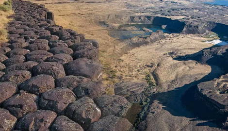
This is not the only place with alien-looking rock formations, though. The Scablands is filled with areas characterized by hexagonal basalt columns. Drumheller Channels is filled with small, isolated buttes with steep basalt-lined sides made up of thousands of hexagonal columns. Geologically spectacular, it is unusual to see geometric patterns on such a grand scale in nature.

The ancient riverbeds of the Scablands also feature large potholes formed by powerful water vortices called “kolks.” These kolks gathered such vigor that they were able to pluck basalt columns out of the earth underneath them, leaving behind large holes in the bedrock. The movement of the water continued to grind and erode the holes until the rocky surface was smooth.
Difficult to identify on the ground, the massive ripple trains are evident when seen from the air. As typically seen in rivers and on beach sand, the movement of water can cause a sequence of small ridges to form on the ground surface. This also happened in the Scablands, except on a scale that is absolutely gargantuan. Instead of leaving marks in the sand, the fast-moving water deposited sediment in the form of rocks and boulders. This sediment formed patterns of consecutive ridges that can be seen clearly from the air.

Filled with wondrous sights that hold incredible geological stories behind them, the Scablands is a place that is truly unique. For hikers, climbers, geologists, or those just wishing to appreciate the distinctive vistas, there is no place quite like it anywhere else in the world.