In Britain, the county of Cornwall draws holidaymakers every summer to enjoy its sunny beaches and blue skies. Yet this little county is filled with history. Dotted boldly around the coastline and tucked secretly away from the winding country roads are historical gems that paint a historical picture of the Cornish countryside spanning several thousand years. This article explores nine historical and magical places, including castles commissioned by Henry VIII, a towering monument, and mesmerizing stone structures, that you must visit when in Cornwall.
1. Walk Among the Hurlers Stone Circles

Across England, there are around 150 prehistoric stone circles, and in the county of Cornwall, 16 of these circles are found in a place called Bodmin Moor, which is Cornish granite upland. The Hurlers draw plenty of attention owing to the fact that they are a group of three stone circles arranged in a line. They date back to the late Late Neolithic (2,900 BCE to 2,200 BCE) or early Bronze Age (2,600 BCE to 1,600 BCE) periods. These ceremonial stones are said to hold the remains of men who were petrified for playing hurling, an ancient Gaelic Irish outdoor team game, on a Sunday.

Less than 10 minutes down the road, you’ll find King Doniert’s Stone, erected sometime in the 9th century. There are two stones that are believed to have once been Celtic crosses stood side by side. One holds an inscription that reads “Doniert rogavit pro anima,” meaning “Doniert has asked [for this to be made] for his soul[’s sake’].” The inscription is believed to commemorate the Cornish king, King Dungarth (also spelled “Dumgarth” or “Dwingarth”). The connection between “Doniert” and “Dungarth” was made using an early Welsh chronicle. Doniert was the King of Dumnonia who drowned at sea sometime around 875 CE.
2. Explore the Lost Gardens of Heligan

About an hour southwest of King Doniert’s Stone sits the Lost Gardens of Heligan, or “Lowarth Helygen” in Cornish, meaning “willow tree garden.” The gardens date back to the mid-18th century, though the estate itself was purchased by Sampson Tremayne in 1569. The Cornish family lived on the estate until just after World War I. The name “The Lost Gardens” is given owing to the lost years between 1914 and 1990, during which the gardens were thought to be in a state of disrepair beyond recovery. Fortunately, the estate underwent a major and very successful restoration in the 1990s. The project was televised and drew a lot of support.

Since its restoration, the estate has enjoyed great publicity. The garden is a very popular attraction and is home to Europe’s only pineapple pit, a method for growing pineapples in colder climates.
Within the estate lies Heligan House. Despite Sampson Tremayne purchasing the Heligan estate in 1569, Heligan House was not erected until 1603. Built in a Jacobean style, it underwent several rebuilds and extensions in the 1600s and 1800s. Today, only the original basement remains, and the house has been divided into flats that have been sold off to private owners.
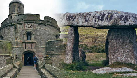
3. Read Latin Inscriptions Along the Walls of St Mawes Castle

St Mawes Castle is both visually stunning and a location of great importance for historians interested in King Henry VIII, the “Rough Wooing” of Scotland, and the second invasion of France. St Mawes Castle was erected as one of several forts built by the King between 1539 and 1545 in a bid to counter any invasion by Catholic France and the Holy Roman Empire. The castle has a clover-leaf shape and originally had octagonal defenses surrounding it, armed with a total of 19 artillery pieces. Its sister castle, Pendennis, can be seen across the estuary. Latin inscriptions praising King Henry VIII and Prince Edward VI, Henry’s son, can be found in the castle.
Beyond the reign of King Henry VIII, the castle served as a fort in the 18th and 19th centuries, undergoing redevelopment and eventually becoming a barracks in the 1850s. Quick-firing guns were installed in the 1880s and 1890s before being removed in 1905. It was run as a tourist attraction until World War II when it briefly housed an anti-aircraft gun to defend against Nazi German attacks.
4. Step into the 16th Century at Pendennis Castle

Pendennis Castle, as mentioned above, was erected alongside her sister castle, St Mawes, by Henry VIII between 1540 and 1542. The castle boasts a circular keep and gun platform, which survived a long siege in the 1600s during the English Civil War (1642 to 1651). It was held by Royalists and finally taken by Parliament in 1646 and was soon after put through restoration by Charles II in 1660.
The castle has a riveting military history, receiving modernization of its defenses in the 1730s and 1790s out of fear of a French invasion and then hosting 48 guns during the Napoleonic Wars. Between the 1880s and 1890s, an electrically operable minefield was set out across the River Fal, controlled by both Castle Pendennis and Castle St Mawes. Pendennis Castle was rearmed in World War I and World War II out of fear of a German invasion and later decommissioned in 1956. The castle is open to the public and hosts various historically-themed events such as knights’ tournaments and jousts.
5. Look Across the Lands at Basset Monument

Basset Monument sits atop a hill, 738 feet above sea level, and overlooks the nearby mining towns of Camborne and Redruth. Ascend to the top of the hill, where it is thought a giant once lived, and you will not miss the monument. Towering at an impressive 90 feet, the monument is a granite Celtic cross erected to commemorate a local mine owner, Francis Basset. He grew popular following his work to improve conditions for miners in his employment.
Historians hold mixed views on the extent of his kindness and generosity; although he was opposed to the transatlantic slave trade (not a commonly held position at the time), he and his family could have done more for the miners. That being said, it’s thought that over 20,000 people attended his funeral, with mines shut down for the procession on the day.
6. Descend into the Depths of the Halliggye Fogou

A fogou (pronounced “foogoo”) is a dry-stone structure built fully underground. Less than 15 fogous have been found across Cornwall, and all date back to the Iron Age or can be linked to Romano-British-defended settlement sites. The Halliggye Fogou is one of the largest to explore and has a series of passages that have been very well preserved.
This particular site has been linked to Iron Age settlements, dated at around 5th-4th century BCE, and it’s thought that it served as a place of either storage or refuge or possibly even as a space for rituals or shrines. It would have been part of a small farming settlement, thought to have been lived in under occupation by the Romans until the end of the Roman period. Bring a torch to explore the full depths of the cave, and be warned of slippery conditions and a steep set of stairs that provide access.
7. Cross the Causeway to St Michael’s Mount

In Cornish, St Michael’s Mount is known as “Karrek Loos yn Koos,” meaning “hoar rock in woodland.” The mount is, in fact, a small tidal island that boasts a castle and chapel. It is co-managed by the National Trust and the St Aubyn family; the latter has called it home since 1650.

The mount has a rich history, with evidence of habituation in the Neolithic period and a monastery in the 8th-11th centuries. A castle was built in the 12th century. Thereafter, the history of the Mount is somewhat unclear, but by 1811, there were over 200 people living on the island. Following a decline in population, the village was largely demolished in the 1850s; however, the castle survived and was romanticized during the 18th and 19th centuries and fortified during World War II. As accessibility via the causeway is weather and tide-dependent, it is essential that all visits are planned in advance.
8. Gaze upon the Megalithic Tomb of Lanyon Quoit

Lanyon Quoit is a single-chamber megalithic tomb, known often as a “dolmen” or “portal tomb.” These tombs are distinguished by two or more upright large stones, called megaliths, supporting a “table” stone, which is a large flat horizontal capstone.

William Borlase, a Cornish geologist and naturalist, captured how Lanyon Quoit looked in 1769, which is remarkably different compared to what you’ll see today. This is because it collapsed during a storm in 1815 and was re-erected nine years later. The original structure was much taller, with the capstone held up by four monoliths. Upon re-erection, the capstone was placed on only three monoliths. Still, the structure is impressive and definitely worth the visit.
9. Dance with the Merry Maidens Stone Circle

A charming circle of 19 stones comprises the Merry Maidens, also known as “Dawn’s Men.” These granite megaliths are between 1.2 and 1.4 meters tall and are situated 3-4 meters apart. The circle is 24 meters in diameter and dates back to the late Neolithic period. Although it’s thought that there were originally 18 standing stones, and some have been added in reconstruction efforts throughout the years, historians agree that the circle stands much like it would have stood when it was erected sometime between 4100 and 2,500 BCE.
The stones gradually become smaller from the southwest to the northeast. New research suggests that some of the oldest stone circles found in Britain were built to be in alignment with lunar and solar positions, so perhaps the layout of the Merry Maidens also reflects the moon’s cycle. Legend says that the Merry Maidens were a group of local girls, who danced on the Sabbath and were petrified to stone.