Getty map is a unique 14th-century nautical illustration. Overall, Christie’s auction house sold it for $239,400 but soon became known that the map’s worth was $7.5M. The auction house organized Gordon Getty and his wife’s assets purchase, with a possible virtual tour. Prior to months of research, Christie’s placed the items dating between 1525 and 1500.
Getty Map Much Older Than Christie’s Estimation

Sifting through property sales in search of hidden gems gained traction on social media. Alex Clausen’s eye caught genuinely antique artifact among a well-known couple’s possessions. The auction house estimated the map’s value between $100,000 and $150,000. We can conclude that it sold for much more than the estimated value of the auction house, and for much less than the true value.
In 1993, Getty and his spouse also acquired it from Christie’s through an auction. Clausen, president of Barry Lawrence Ruderman Antique Maps Inc., had a strong suspicion that it was considerably older. For $239,400, Clausen and his group bought the map at Christie’s in October of the prior year. Clausen and his team concluded after several months of investigation that the vellum map was probably created in Venice around 1360.

The research included carbon dating evaluations, pigment research, multispectral scans, and discussions with academics and catalogers. The purchase from the Getty estate became the oldest portolan graph in the United States with this new date. It is even older than the ones owned by the business moguls and portolan hunters Henry Huntington, J. P. Morgan, or James Ford Bell.
Get the latest articles delivered to your inbox
Sign up to our Free Weekly Newsletter
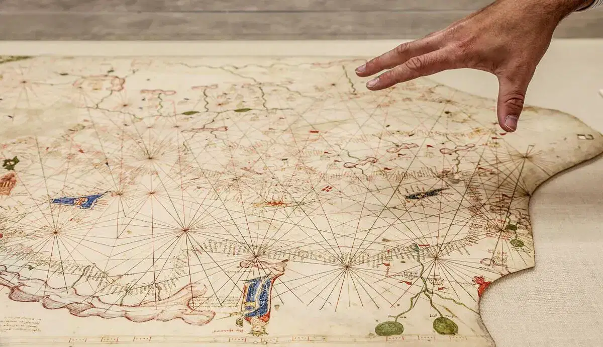
The Rex Tholomeus Portolan Chart of 1360

The map is even older than the ones on display at the Morgan Library and Museum and Yale University’s Beinecke Rare Book and Manuscript Library. Clausen’s is additionally the fourth-oldest European portolan graph still in existence. The map Clausen bought from Christie’s last fall originated about 130 years before Columbus first arrived in the New World, which helps to put the time frame in perspective.
Clausen and his team named the map the Rex Tholomeus Portolan Chart of 1360. It got the name etailed homage to Claudius Ptolemy, the 2nd century historian, mathematician and geographer. The map’s origin details include Pietro Amat di San Filippo, an Italian scholar, who made the first exploration of it.

The Rex Tholomeus Portolan Chart of 1360 has an entry on the Barry Lawrence Ruderman Antique Maps website that states, “price on request.” the company’s CEO, Barry Lawrence Ruderman, said that the price is $7.5 million.


