The Tang Dynasty (618–907 CE) succeeded the Sui Dynasty and is widely considered a golden age of cosmopolitan Chinese civilization, characterized by significant territorial expansion along the Silk Road, economic prosperity, and a flourishing of arts, poetry, and culture.
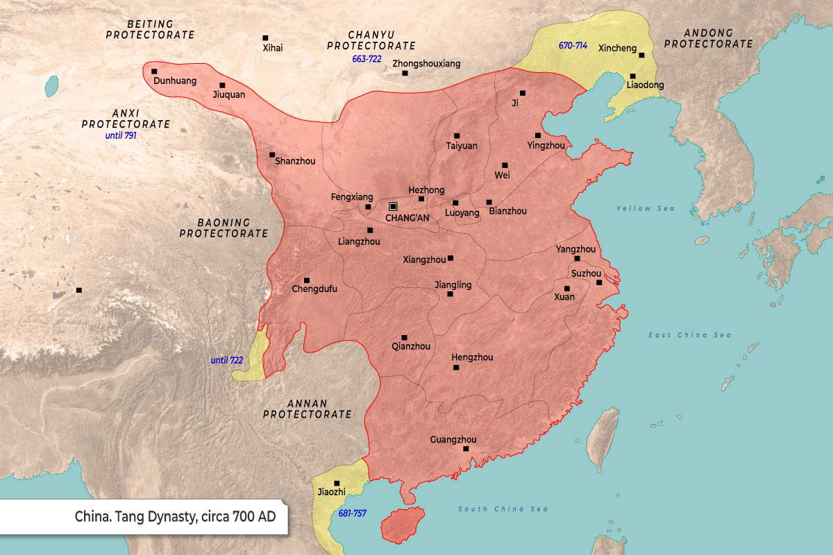
The map illustrates the territorial extent and administrative divisions of China during the Tang Dynasty, circa 700 AD.
The map uses a large red-orange shaded area to denote the core consolidated territory of the Tang Empire.
- Peripheral regions shaded in yellow indicate territories under temporary control, with specific date ranges provided for these occupations (e.g., 663-722, 670-714).
- Surrounding the main empire are several frontier zones labeled as “Protectorates,” which served as buffer regions and spheres of influence.
- Black squares mark significant cities, with the central capital of Chang’an distinguished by a square containing a white center.
| Region / Protectorate | Territorial Status / Dates | Marked Cities |
| Main Tang Empire |
Core Territory
|
Chang’an, Luoyang, Taiyuan, Wei, Ji, Yingzhou, Bianzhou, Hezhong, Fengxiang, Shanzhou, Liangzhou, Xiangzhou, Jiangling, Chengdufu, Qianzhou, Hengzhou, Guangzhou, Yangzhou, Suzhou, Xuan, Jiuquan, Dunhuang
|
| Andong Protectorate |
670–714 (Yellow Region)
|
Xincheng, Liaodong
|
| Chanyu Protectorate |
663–722 (Yellow Region)
|
Zhongshouxiang
|
| Annan Protectorate |
681–757 (Yellow Region)
|
Jiaozhi
|
| Beiting Protectorate |
Frontier Zone
|
Xihai
|
| Anxi Protectorate |
until 791
|
None marked
|
| Baoning Protectorate |
Frontier Zone
|
None marked
|
| Southwest Border |
until 722 (Yellow Region)
|
None marked
|