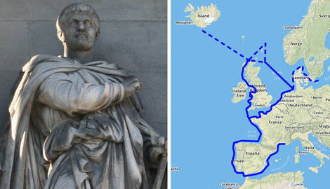
The ancient Greeks were renowned for their love of the sea and their voyages of exploration, immortalized in their own mythology with great hero-explorers such as Odysseus and Jason and the Argonauts. While famous for their traveling and for setting up colonies all around the Mediterranean in the Archaic and Classical periods, the voyage of Pytheas is less-known. From the colony of Massalia in southern Gaul, Pytheas went further than any Greek before him, out through the Straits of Gibraltar and north, to the vast frozen stretches of the North Sea!
Pytheas: Explorer or Storyteller?

The story of Pytheas of Massalia is one of two extraordinary feats: his own voyage, along the coast of Portugal, Gaul (France) and around Britain, perhaps all the way to Iceland, and that of his story, his retelling of his journey.
Tragically, the latter, known as On the Ocean, is all but lost to us. What survives of the original exists only through mentions by other ancient geographers and historians, like Strabo and Polybius. These later sources, looking back to the late 4th century BC Pytheas, viewed his journey with a critical eye, disparaging him as a spinner of tall tales and doubting the veracity of his account (e.g., Strabo, Geography, 1.4.3). To that end, they cited sections of Pytheas’s work in their own, which is how it survived in fragmentary form to this day. Ironically, then, the same men whose aim was to discredit him ensured his account came down to us, all those centuries later.
That is not to say that Pytheas was a conman or seen universally as such by his near contemporaries. Writing a few centuries later, in the 1st century AD, Pliny the Elder refers to Pytheas in his Natural History (e.g., Book 37.11), for information regarding the movement of the tides based on the lunar phases, the existence of amber deposits in the Baltic, and the shape of Britain and how long it would take to circumnavigate it.
Much of what Pytheas wrote, filtered through the works of others and undoubtedly warped, seems strikingly accurate! Let us follow him along his voyage ourselves.
The Voyage Begins

The voyage must have taken place sometime in the latter part of the 4th century BC. At this point, Massalia (modern-day Marseille), a city founded by Greeks from Phocaea at c. 600 BC, was a flourishing trade metropolis and a key port in the Western Mediterranean. However, the Carthaginians had effective control of the sea in the west, and closely guarded the Pillars of Herakles (Straits of Gibraltar) against non-Carthaginians, to protect their trade interests in the Atlantic.
This has led to some speculation that Pytheas, whose actual identity and function within Massalia remain unknown to us, somehow took his ship overland to the mouth of the Loire or the Garonne rivers, and came out somewhere around Bordeaux, to avoid the Carthaginian embargo. This forms the basis of one of Strabo’s doubts: Polybius, quoted by Strabo, refuses to accept that a private citizen would have had the means to fund such an expedition on his own (Strabo, Geography, 2.4.2). However, others have pointed out that Massalia is not reported to have had any conflicts with Carthage, and its ships may thus have been allowed to sail where they pleased.
Eratosthenes, quoted by Strabo, has Pytheas noting that the tides ended at the Hieron acroterion, the sacred promontory, from which the journey back to Gades/Gadeira (modern-day Cadiz) was five days sailing. The sacred promontory has been identified with Sagres Point in Portugal, located at the southwestern tip of continental Europe. This is taken as proof that Pytheas had indeed sailed through the Straits of Gibraltar and up the coast of Iberia.
On Britain’s Shores

Constrained by the naval technologies of his time and the need to resupply and trade, Pytheas must have done as all Greeks did, and sailed close to the coast, at least until his journey turned northwards, towards the British Isles. Strabo, who doubts that Pytheas ever went through the Pillars, citing Polybius (Geography 2.4.2), begrudgingly admits the accurate placement of various locations and peoples along the coast of Gaul and Brittany, by citing him directly, without further comment (Geography, 4.4.1).
He, however, still mocks Pytheas for his outlandish claims of Britain’s triangular shape and the measurement of its perimeter at 40,000 stadia (roughly 4,000 miles) (Geography, 1.4.3). Pytheas could not have fully accounted for the particularities of the British coastline, especially around Scotland, but his identification of Britain as a triangular island was strikingly accurate. Indeed, he was one of the first to identify Britain as an island at all!
According to Pytheas, its three corners were Kantion (Kent), Belerion (Cornwall), and the Orkas (Orkney Islands). He called this strange, rainy, mist-covered island “Prettanike” or “Brettanike.” As such, the name of world-conquering Britain comes from the mouth of an ancient Greek.

The historian Diodorus Siculus, who never traveled to Britain, describes in his own work how tin mining operated in ancient Cornwall (Belerion). Miners smelted tin into “knuckle-bone” shapes and took them, at low tide, to the island of Ictis, identified with St. Michael’s Mount. While he does not cite Pytheas, it is very likely that he is Diodorus’s source for this information, another piece of evidence towards his having made the voyage.
The Greeks, much like the Carthaginians, always had their eyes and ears open to new opportunities for trading in valuable raw materials. Diodorus, thus potentially quoting Pytheas, describes the inhabitants of Cornwall as “very fond of strangers and […] civilized in their manner of life” (Library of History, 5.22.1).
Forward, to Ultima Thule!

Having thus explored Britain and reached its northernmost point in the Orkneys, Pytheas sailed for six days in the open ocean until he reached the mysterious land of Thule. The ancient astronomer Geminos, quoting Pytheas, identifies this region as where the “sun goes to rest,” accounting for the extreme shortness of the nights there. This once again confirms that Pytheas did not make his voyage up.
Thule, according to Pytheas, was a land reliant on agriculture but at the mercy of endless rain and lack of sun—a nightmare to the Greeks—so much so, that grain had to be threshed indoors (Strabo, Geography, 4.5). Since the Venerable Bede’s identification of Thule with Iceland in the 8th century AD, people have been tempted to identify Pytheas’s Thule as such. However, the island was apparently uninhabited until around Bede’s time, making this hypothesis a more tenuous one. Its inhabitants made a drink from “grain and honey,” an early reference to mead, which might favor connecting Thule to Norway over Iceland, as the latter’s climate is less suited to bee-keeping.
Where the Universe Began to Come Apart

Wherever Thule was, Pytheas thought to go even further and sailed one day more to the north. We can only imagine what the ancient Greek mariners must have felt as they came up to where the universe, as they understood it, began to come apart. There, land, sea, and air—key elements of the world’s composition in the Greek mind—all blended into one, a mixture Pytheas called pneumon thalattios, a “sea-lung” on which one could not walk and through which one could not sail (Strabo, Geography, 2.4.1).
As if to reassure whoever read his account that he, too, understood how bizarre this sounded, Pytheas added that he saw this with his own eyes (Strabo, Geography, 2.4.1). Strabo, of course, did not believe this account in the least. Today, we know that this was likely “pancake” or “slush” ice, at the outer edges of a drifting ice pack, which often comes with dense sea fog that appears to move with the rhythm of the ocean swell, creating the illusion of breathing, like a lung!
Having witnessed these otherworldly sights, the Greeks turned back south, perhaps down the eastern coast of Britain, and then might have sailed eastwards into the Baltic Sea, witnessing the coasts of Germany and Scandinavia. Pliny the Elder mentions that Pytheas encountered the Guiones (or Gutones), a Germanic tribe situated near an estuary, potentially the Elbe (Pliny the Elder, Natural History, 37.35).
A Trade Secret No More!

A day’s sail away from there, an island is described, named Abalos or Basilia, where “amber is thrown up by the waves in the spring, being an excretion of the sea in concrete form” used by the islanders as fuel for their fires or sold to their neighbors, the Teutones (Pliny the Elder, Natural History, 37.35-36). For the Greeks, this must have been an incredible discovery, as amber, electron in Greek, was a sought-after luxury item, whose provenance was somewhere in the north, but heretofore unknown to them.
Little is known about Pytheas’s return journey to the Mediterranean. Polybius and Strabo mock Pytheas for the extreme claim of his having “traversed the entire ‘coastline’ of Europe towards the Ocean from Gadeira [Cadiz] to the Tanais [River Don]” (Strabo, Geography, 2.4.1). While this might suggest that Pytheas made use of river systems in northern Europe to avoid traveling along its Atlantic coast, here we must grant Polybius and Strabo their skepticism.
The Greeks fundamentally believed that the inhabited world was surrounded by a great Ocean, connected to the inner sea, the Mediterranean, by great and branching rivers. For example, it was a long-held belief that the River Nile somehow communicated with the Indian Ocean, its source somewhere along the southeastern coast of Africa. Today, of course, we know better, and it is very likely that Pytheas made his return along the same lines he set out on, passing by the Atlantic coast of Gaul, Spain, and Portugal, and re-entering through the Straits of Gibraltar.
An Explorer Remembered

Whoever Pytheas was, and despite the best efforts of his detractors, he will always be remembered as one of the greatest explorers of antiquity who went further than anyone had before. While Alexander was pushing the boundaries of Greek knowledge in the Far East, in Central Asia and India, Pytheas was doing the very same in the Far West and Far North, in Britain, the North and the Baltic Sea. Just as Alexander reached the Hyphasis River in India, in 326 BC, we can imagine Pytheas and his crew making their first forays into the “sea lung” north of distant Thule.
Bibliography
Strabo, Geography.
Diodorus Siculus, Library of History
Pliny the Elder, Natural History
Cunliffe, B. W., The extraordinary voyage of Pytheas the Greek, (Walker Books, 2002).
Scott, L., Pytheas of Massalia: Texts, Translation, and Commentary, (Routledge, 2022).