The maritime civilization of Carthage in North Africa was always looking for ways to expand its influence through trade and the establishment of colonies in new lands to secure access to luxury goods. Well before its clash with Rome, one such expedition was mounted under a man called Hanno, sailing from Carthage beyond the Pillars of Herakles (Straits of Gibraltar) and south along the western coast of Africa. The account of this wondrous voyage contains incredible information about these strange lands and the people inhabiting them in antiquity.
Setting the Stage

Before the grand voyages of exploration by the Portuguese and the Spanish in the Early Modern Period, the corners of the map, beyond the Mediterranean, were shrouded in mystery. Sea monstrosities indicating danger represented them, and for centuries after the end of antiquity, these warnings were very much heeded by mariners. While Arabs, Persians, and Indians traded by sea, across the Indian Ocean, for the Europeans, their only way out of the Mediterranean was the Atlantic, a seemingly endless stretch of water beyond the Pillars of Herakles (the Straits of Gibraltar), perceived as the domain of monsters, a place of oddities, and the bane of foolish captains.
Yet, more than a millennium before Columbus, a seafaring civilization braved the uncharted waters for much the same reasons: for trade and for the establishment of colonies in new lands. Anyone familiar with the various cultures straddling the ancient Mediterranean will not be surprised to find the Carthaginians behind this incredible feat.
With their seat in Carthage (in modern-day Tunisia), founded by Phoenicians from the Levant, the Carthaginians expanded their dominion across the coasts of the Western Mediterranean and North Africa, by establishing trade stations which soon developed into proper colonies. They grew rich and powerful by procuring and trading faraway commodities and luxuries, linking East and West with their ships. Indeed, the further away and the more difficult a product was to acquire, the more lucrative the profits for the merchant.
It is no wonder, then, that at some point, in the 5th century BC, they decided to explore even more distant trade opportunities, this time beyond the Pillars of Herakles! Enterprising, daring, and with a keen eye for profit, these were the Carthaginians who would one day be the greatest rival of the fledgling Roman Republic.
Hanno and His Account

The account of the voyage—the longest text we have from the Carthaginian civilization—comes down to us through several intermediaries. It was initially put up in the temple of Kronos (the Hellenized version of Baal Hammon) in Carthage, by Hanno himself after his voyage. Greek writers in the 5th century BC translated and recorded the text, references to which appear in the work of Herodotus and Arrian. Afterwards, the text was copied at different points by the Romans, the later Byzantines, and early modern scholars, and thus much of the information might have been lost or altered. It nonetheless makes for an incredibly interesting read, and its title, the Periplus of Hanno, already tells us that it was a voyage along the coast, in the ancient Greek manner.
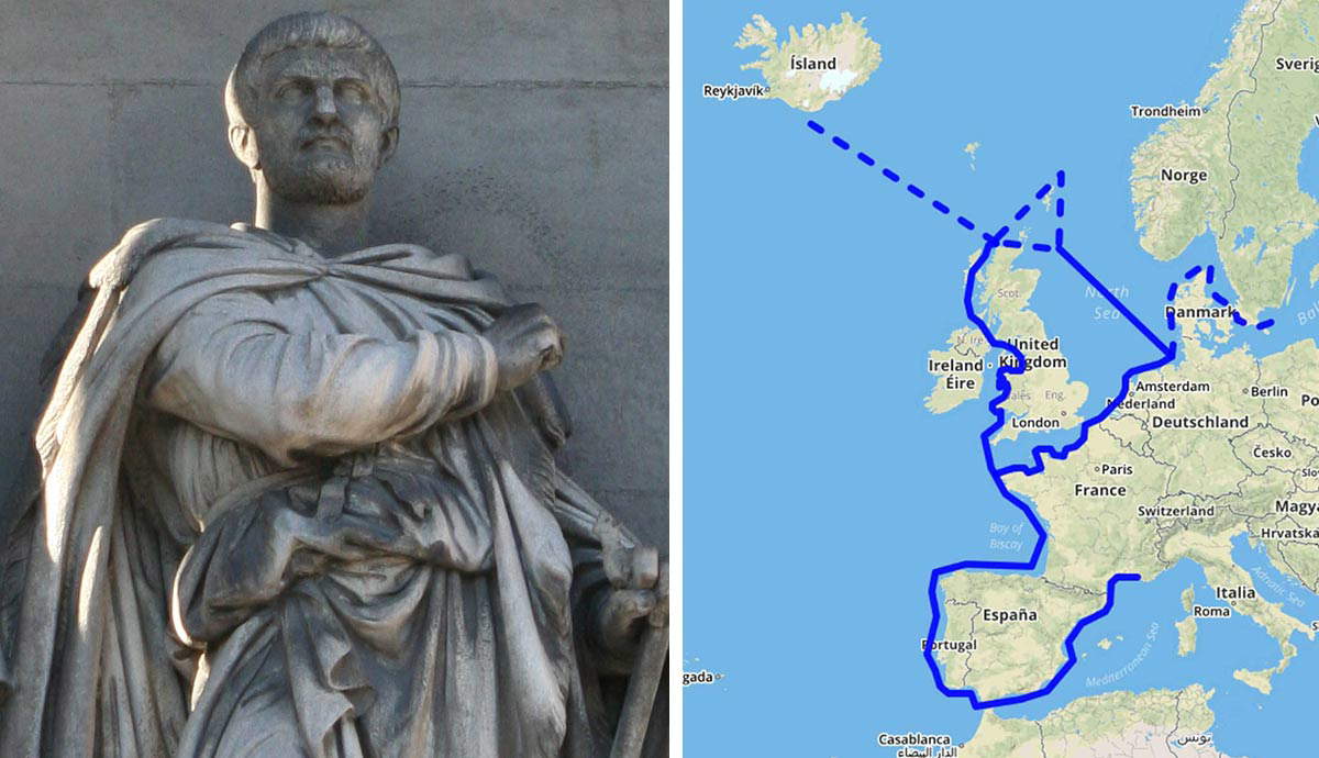
The eponymous Hanno was chosen to lead the voyage, and not much more is known about him beyond this. He is referred to as “basileus,” king, in the Greek translation, and thus might have belonged to one of Carthage’s noble families and been a high-ranking official, also known as a “suffette.” Regardless, as the account suggests, his mission was to found a number of colonies along modern-day Morocco’s Atlantic coast.
For this, he was given “sixty fifty-oared ships” and “about thirty thousand men and women” along with the necessary supplies and equipment. The numbers, as is often the case with such accounts, are highly suspect, but what is conveyed without a doubt is the importance of this expedition to the Carthaginians. It was a substantial investment.
The Founding of the New Cities

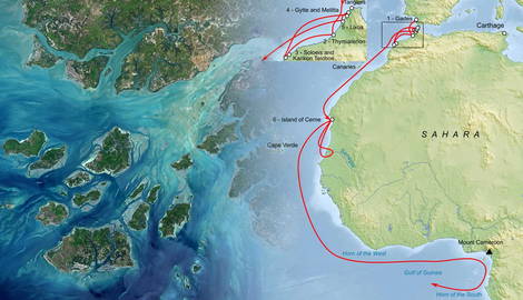
The Pillars were reached uneventfully from Carthage, and after two days of sailing, the first city was founded, Thymiaterion. In Greek, “thymiaterion” means incense-altar, but this may be a misinterpretation of the Phoenician word “dumathir,” which means flatland or city-on-the-plain, and in fact, the account mentions that “below it was a large plain.” Scholars have placed it in the location of the modern-day Mehdya, relatively close to Morocco’s Rabat.
At a place called Soloeis, nearby, a temple to “Poseidon” was dedicated, and then, a slew of other cities were founded: Karikon Teichos, Gytte, Akra, Melitta, and Arambys. Karikon Teichos may, again, be a Greek interpretation of “Kir Chares,” meaning “Castle of the Sun,” and at its associated location, at Azzemour, Carthaginian-style tombs have been found. At the purported site of Gytte, in El-Jadida, a Carthaginian necropolis has been discovered. Akra may be the Greek rendition of “Hakra,” meaning castle in Phoenician, indicating a fortified colony. Melitta still retains its ancient name as Oualiddia, and Arambys might have been “Har Anbin” in Phoenician, meaning “Grape Mountain.” Its location has been identified with the islet of Mogador, across from Essaouira, and Carthaginian-style pottery has been recovered there.
Indeed, Arambys may be the city with the most long-term importance, as very soon it was turned into a site for the extraction of purpura from shellfish, the fabled Tyrian purple, which would one day become the color of imperial Rome’s senatorial elite and of the emperor himself. Under Augustus, a Roman presence may have been established on the island, where coinage and even the foundations of a Roman-style house have been found, no doubt to secure the supply of the precious dye.
The Lixites and Kerne

Soon after, they reached the Lixos River, whose location is disputed among scholars, but might have been the Draa River, across from the Canary Islands. There, favorable diplomatic contacts were made with a tribe of local pastoralists, the Lixites. Nearby, hostile tribes of “Ethiopians” dwelled, occupying a land full of wild animals. “Ethiopian” was what the ancient Greeks called native Africans, especially those of darker complexion, as opposed to the “Libyans” of North Africa. On a mountain range close to them, according to the Lixites, a “strange people” lived in caves, able to run faster than horses. These mountains might have been the Rif Mountains, but it is uncertain.
As a result of the positive relations with the Lixites, interpreters from their tribe accompanied the Carthaginian expedition as they sailed south along the desert coast. They then reached an island they called “Kerne,” from the Carthaginian “Chernah,” meaning “last habitation.” This island may have been Herne Island, in the bay of Rio de Oro (Dakhla, Morocco), or one of the islands in the Bay of Arguin, across the coast of Mauritania.

Hanno claims that this island lies at the opposite end of Carthage, as it took them the same time to sail from Carthage to the Pillars of Herakles, as it did from the Pillars to Kerne. The name “Chernah” was given to it because, as the account itself suggests, this was where they settled the last of their colonists. The rest of the voyage would be one of pure exploration.
After crossing a river called “Chretes,” possibly from the Phoenician word “Cheremat” for river, they reached a bay containing three islands, all of them larger than Kerne. At the end of the bay, and three days sailing later, they encountered “savages clad in animal skins” who threw stones at them and prevented them from making landfall.
Into the Gulf of Guinea

The location of the River Chretes is uncertain, and we must keep in mind that 2,500 years later, many aspects of the landscape may have changed. The river they reached sometime afterward, however, broad and “teeming with crocodiles and hippopotamuses,” is very likely the Senegal River. From there, they briefly returned to Kerne before continuing their journey to unknown shores.
From the Senegal River, they sailed twelve days south, encountering yet more “Ethiopians” who fled from them as they approached and whose language was unintelligible to the Lixite interpreters. This was undoubtedly new terrain for all involved. If one assumes that the distance they covered in a day was equal to 100 kilometers (62 miles), then these new lands might have been Guinea, around modern-day Sierra Leone. These were ancient indigenous people of the coastal regions of Guinea, possibly with some connections to the Limba, before the migrations and demographic changes of the Medieval and Early Modern Periods.
At the end of the twelve-day journey, the Carthaginians anchored “by some big mountains,” which, as Hanno, ever the intrepid trader, noted, were covered by trees of an aromatic and colorful wood. Past these mountains, possibly close to the modern-day Ivory Coast, it is mentioned that the land gave way to a large stretch of water, which might indicate that the southernmost tip of the coast the Carthaginians had been straddling opened up into the Gulf of Guinea to the east. Inland, during the night, they observed “big and small fires everywhere flaming up at intervals.”
Smoke on the Water, Fire in the Sky

Having replenished their freshwater supplies, the Carthaginians continued eastward along the coast for five days, until they reached a bay which the Lixite interpreters called “the Horn of the West.” There was a large island there, with a saltwater lagoon containing yet another island! There, the expedition disembarked, and while the day was uneventful, the night was to be one of terror. Distant fires glowed in the tropical darkness, and flutes, pipes, cymbals, and great drums echoed across the island.
The Carthaginians were overcome by fear, and their soothsayers wisely advised them to abandon the island then and there. Its identification remains uncertain. W. H. Schoff, on whose translation we are relying, places it among the Bissagos Islands off the coast of Guinea-Bissau.

The terrors would not end there, however. As they sailed away, “quickly and in fear,” for four days, they saw the coast engulfed by flames. Red streaks of the inferno ran everywhere, and one of them appeared to be rising to the stars. Only by day could they infer that this fire came from the top of a very tall mountain, which was called “the Chariot of the Gods.” This has been identified with Mt. Cameroon, one of the largest volcanoes in Africa, at 4,040 meters (13,254 feet). Even today, in the language of the native Bakweri people, it is called “Monga-ma Loba,” which translates to “seat of the gods” or “mountain of the gods.” The ancient Greek rendering of this should have been “theon oikema,” which could have easily been corrupted by a later scholar into “theon ochema,” meaning “vehicle” or “chariot of the gods.” Terrifyingly, it is also one of Africa’s most active volcanoes, erupting often in the 20th and 21st centuries—most recently in 2012!
Hanno was right to fear this intimidating mountain, whose prowess inspired awe for more than 2,500 years after his visit. Three days sailing along the coasts of fire, the Carthaginians arrived at “the Horn of the South,” another bay, identified with Corisco Bay, close to Gabon. This was the site of the most interesting encounter of the journey—and the last to be mentioned.
The Voyage’s Eventful Conclusion

Here, according to Hanno, was an island which was inhabited by savages, most of them women, “with hairy bodies,” whom the Carthaginians’ interpreters called “gorillas.” The crew of the expedition chased them down, but to no avail, as they were very good climbers and threw stones at them. Despite this, three of their women were caught, but refused to come in peace, biting and scratching their assailers, and therefore were killed and flayed. Their skins, or rather, furs, were taken back to Carthage and, according to Pliny the Elder (Natural History, 6. 36), were displayed in the Temple of Tanit until the city’s razing by the Romans.
As gorillas cannot cross large bodies of water, this might have taken place on the mainland instead, mistaken by Hanno for an island due to its proximity to the sea. Moreover, gorillas are not known for throwing rocks, whereas chimpanzees are, which might have been what the Carthaginians actually encountered. In the 19th century, American physician and missionary Thomas Staughton Savage and naturalist Jeffries Wyman classified gorillas as such, based on the descriptions of Hanno!

This was the end of the Carthaginians’ voyage, as their provisions were running low, and by this point, Hanno had not mentioned any more lucrative trade prospects; only hostile locals, animals, and fiery death. The account abruptly ends there, and we are left wondering if there were any more interesting episodes accompanying their homeward voyage.
Nonetheless, the voyage of Hanno was an incredible feat of ancient seamanship. The brave and enterprising Carthaginians, through the words of their leader, showed us that well before Columbus and the explorers that followed him, there was no shortage of men willing to dare to challenge the dangers of the unknown!
Bibliography
Lipiński, E., Itineraria Phoenicia, (Leuven, 2004).
Mauny, R., “La navigation sur les côtes du Sahara pendant l’antiquité,” Revue des Études Anciennes, Année 1955, 57-1-2, (1955), pp. 92-101.
Roller, D. W., Through the Pillars of Herakles: Greco-Roman Exploration of the Atlantic, (United Kingdom, 2006).
Schoff, W. H., The Periplus of Hanno: A Voyage of Discovery down the African Coast, by a Carthaginian Admiral of the Fifth Century BC, (Philadelphia, 1912).